Weather disturbance could develop into Tropical Storm Tammy; forecasters caution residents to monitor its progress
The Meteorological Office (MET) continues to monitor the progress
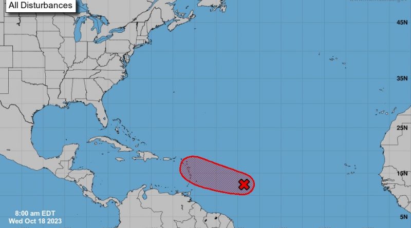
of AL94, which now has a high chance of development.
“Although there is uncertainty concerning its eventual path and
strength, AL94 has the potential to impact the Leeward Islands and
the British Virgin Islands, bringing cloudiness, showers,
thunderstorms and gusty winds as early as Friday, October 20,” MET
officials say.
Forecaster Orvin Paige says the disturbance could develop into a
tropical cyclone over the next few days; and, if it continues to gain
organization, it could become Tropical Storm Tammy.
Paige says AL94 continues to move closer to the Eastern Caribbean.
But, depending upon how close it comes to Antigua and Barbuda,
the other Leewards, and the British Virgin Islands, the specific
nature of its impact will change.
Accordingly, “no specific action is required of residents … at this
time, other than to continue to monitor the progress of AL94,” the
MET Office says.
Meanwhile, the National Hurricane Center (NHC) says that
environmental conditions are favourable for the gradual
development of this disturbance, and a tropical depression is likely
to form within the next 24 to 48 hours.
The system is expected to move west to west-northwestward across
the central and western tropical Atlantic, the NHC says.
According to the NHC, “Regardless of development, this system
could bring gusty winds, heavy rainfall, and flooding to parts of the
Lesser Antilles within the next 48 hours.”
Already, communities across Antigua are reporting heavy clouds
and rainy conditions today, Wednesday.
“I would be happy for the rain, but we can’t manage the wind,” one
woman tells REAL News, adding that she lost several fruit trees
during Tropical Storm Philippe.